
Ofbeeldienge:MapGistel.svg

Afmetingen van deze voorvertoning van het type PNG van dit SVG-bestand: 576 × 600 pixels Andere resoluties: 230 × 240 pixels | 461 × 480 pixels | 737 × 768 pixels | 983 × 1.024 pixels | 1.966 × 2.048 pixels | 818 × 852 pixels.
Ofbeeldienge in een ôgere resolutie (SVG-bestand, nominaal 818 × 852 pixels, bestandsgrootte: 53 kB)
Beschrijving
| Beschrijving |
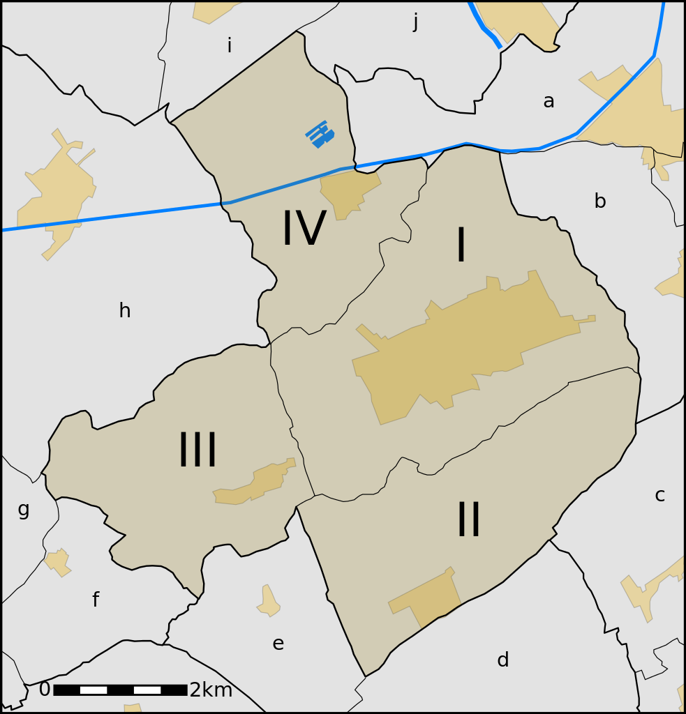
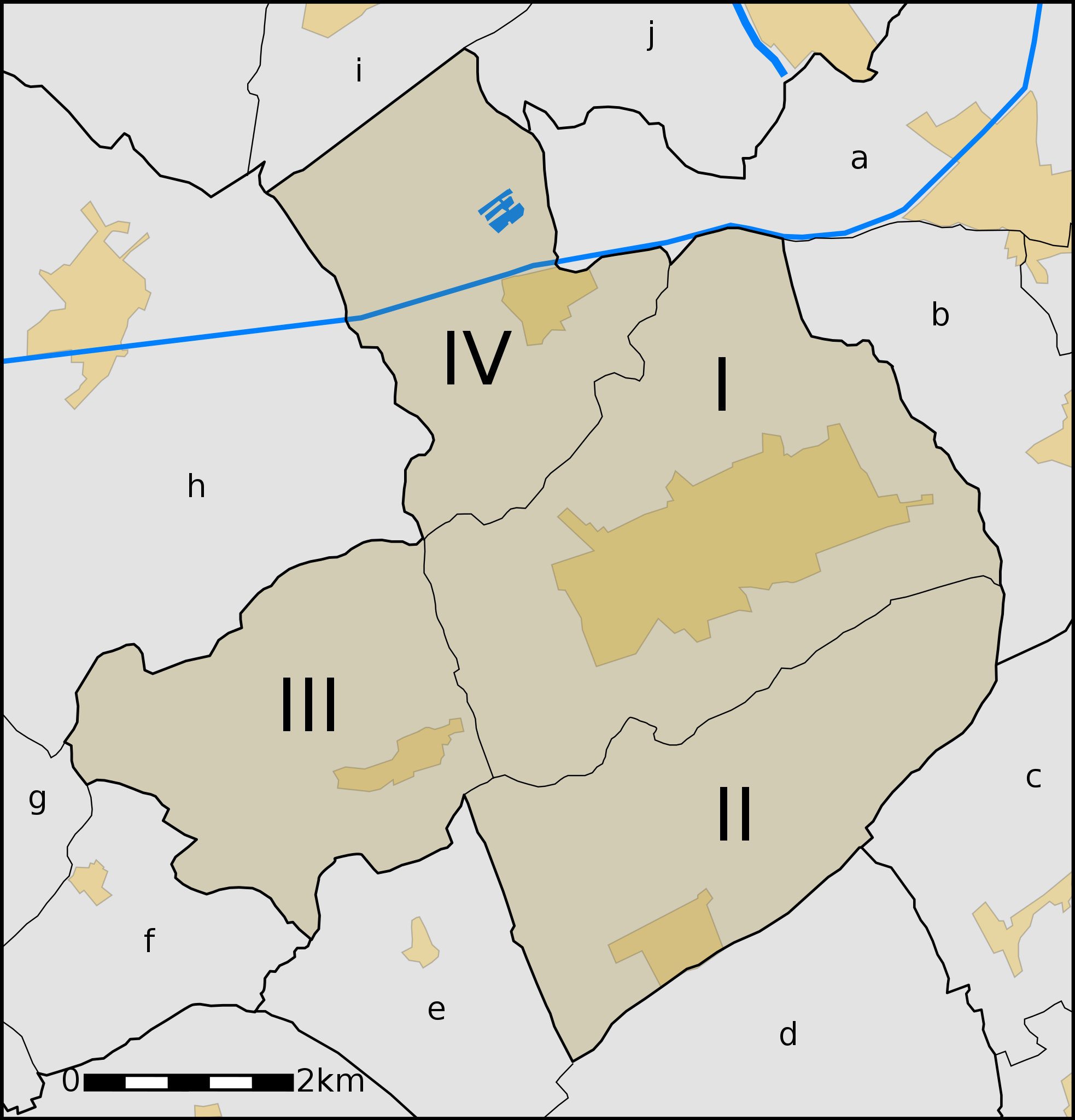
Map of Gistel, West-Flanders, Belgium, towns within the municipality and its neighbours.
Neighbourings villages:
|
| Datum | |
| Bron | Eigen werk |
| Auteur | nl:User:LimoWreck |
Licentie
Ik, de auteursrechthebbende van dit werk, maak het hierbij onder de volgende licenties beschikbaar:

|
Toestemming wordt verleend voor het kopiëren, verspreiden en/of wijzigen van dit document onder de voorwaarden van de GNU-licentie voor vrije documentatie, versie 1.2 of enige latere versie als gepubliceerd door de Free Software Foundation; zonder Invariant Sections, zonder Front-Cover Texts, en zonder Back-Cover Texts. Een kopie van de licentie is opgenomen in de sectie GNU-licentie voor vrije documentatie. |
| Dit bestand is gelicenseerd onder de Creative Commons-licentie Naamsvermelding-Gelijk delen 3.0 Unported | ||
| ||
| Deze licentietag is toegevoegd aan dit bestand in verband met de GFDL licentie-update. |
Dit bestand is gelicenseerd onder de Creative Commons-licentie Naamsvermelding 2.5 Unported
- De gebruiker mag:
- Delen – het werk kopiëren, verspreiden en doorgeven
- Remixen – afgeleide werken maken
- Onder de volgende voorwaarden:
- naamsvermelding – U moet op een gepaste manier aan naamsvermelding doen, een link naar de licentie geven, en aangeven of er wijzigingen in het werk zijn aangebracht. U mag dit op elke redelijke manier doen, maar niet zodanig dat de indruk wordt gewekt dat de licentiegever instemt met uw werk of uw gebruik van zijn werk.
U mag zelf één van de licenties kiezen.
Bestandsgeschiedenisse
Klik op een datum/tijd om het bestand te zien zoals het destijds was.
| Datum/tijd | Miniatuur | Afmetingen | Gebruiker | Opmerking | |
|---|---|---|---|---|---|
| huidige versie | 23 ogu 2006 22:43 | | 818 × 852 (53 kB) | LimoWreck | * fixed layers |
| 23 ogu 2006 22:13 |  | 818 × 852 (53 kB) | LimoWreck | {{Information |Description=Map of Gistel, West-Flanders, Belgium, towns within the municipality and its neighbours. <br/> Gistel: *I. Gistel *II. Moere *III. Zevekote *IV. Snaaskerke Neighbourings villages: *a. Oudenburg *b. Westkerke (Oudenburg) *c. Eern |
Bloadn met dizze ofbeeldienge
Der is/zyn verwyzieng(e)n noar dit bestand ip de volgende bloadn:
Globaal bestandsgebruik
De volgende andere wiki's gebruiken dit bestand:
- Gebruikt op br.wikipedia.org
- Gebruikt op ca.wikipedia.org
- Gebruikt op et.wikipedia.org
- Gebruikt op fr.wikipedia.org
- Gebruikt op fy.wikipedia.org
- Gebruikt op li.wikipedia.org
- Gebruikt op nl.wikipedia.org
- Gebruikt op pt.wikipedia.org
- Gebruikt op ro.wikipedia.org