
Ofbeeldienge:Irish Sea – relief, ports, limits.tif

Afmetingen van deze voorvertoning van het type JPG van dit TIF-bestand: 415 × 600 pixels Andere resoluties: 166 × 240 pixels | 332 × 480 pixels | 531 × 768 pixels | 1.043 × 1.507 pixels.
Ofbeeldienge in een ôgere resolutie (1.043 × 1.507 pixels, bestandsgrootte: 4,5 MB, MIME-type: image/tiff)
Beschrijving
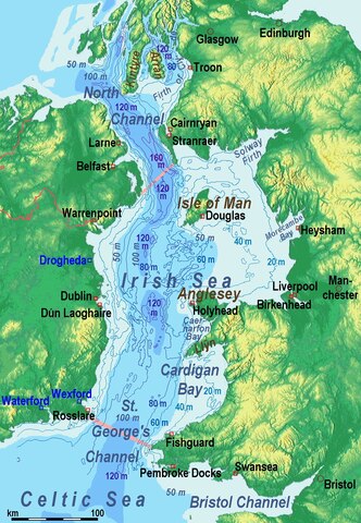
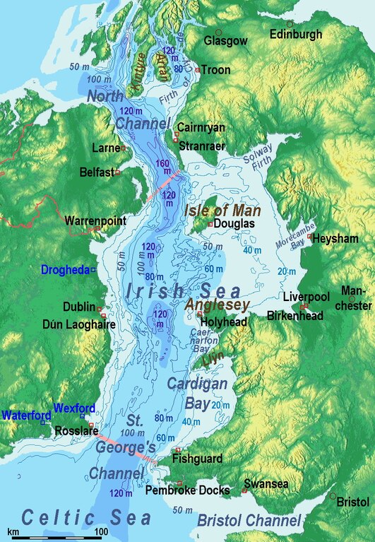
| Beschrijving | Bathysmographic map of the en:Irish Sea. Major ports shown with red marks. freight-only ports in blue. |
| Datum | |
| Bron | Eigen werk, the countures of depth are drawn by myself according to the UK source, the areal colours are derived from the Irish one. The land is from Maps for Free. |
| Auteur | Ulamm (talk) |
| Andere versies |
Sources of information
- internal report Nr. 174 of the National Oceanography Centre (Liverpool)
- http://www.dcenr.gov.ie (Department of Communications, Energy and Natural Resources) -> IOSEA4Annex–Master–r02–Fiinal.pdf (Fourth Strategic Environmental Assessment for Oil and Gas ACtivity in Irelands Offshore Waters) -> figures 2.1 & 2.2a
Licentie
Ik, de auteursrechthebbende van dit werk, maak het hierbij onder de volgende licentie beschikbaar:
Dit bestand is gelicenseerd onder de Creative Commons-licentie Naamsvermelding-Gelijk delen 3.0 Unported
- De gebruiker mag:
- Delen – het werk kopiëren, verspreiden en doorgeven
- Remixen – afgeleide werken maken
- Onder de volgende voorwaarden:
- naamsvermelding – U moet op een gepaste manier aan naamsvermelding doen, een link naar de licentie geven, en aangeven of er wijzigingen in het werk zijn aangebracht. U mag dit op elke redelijke manier doen, maar niet zodanig dat de indruk wordt gewekt dat de licentiegever instemt met uw werk of uw gebruik van zijn werk.
- Gelijk delen – Als u het werk heeft geremixt, veranderd, of erop heeft voortgebouwd, moet u het gewijzigde materiaal verspreiden onder dezelfde licentie als het oorspronkelijke werk, of een daarmee compatibele licentie.
Bestandsgeschiedenisse
Klik op een datum/tijd om het bestand te zien zoals het destijds was.
| Datum/tijd | Miniatuur | Afmetingen | Gebruiker | Opmerking | |
|---|---|---|---|---|---|
| huidige versie | 14 dec 2014 15:17 |  | 1.043 × 1.507 (4,5 MB) | Ulamm | {{Information |Description = Bathysmographic map of the en:Irish Sea. Major ports shown with red marks. freight-only ports in blue. |Source = {{own}}, the countures of depth are drawn by myself according to the UK source, the areal colours are der... |
Bloadn met dizze ofbeeldienge
Der is/zyn verwyzieng(e)n noar dit bestand ip de volgende bloadn:
Globaal bestandsgebruik
De volgende andere wiki's gebruiken dit bestand:
- Gebruikt op azb.wikipedia.org
- Gebruikt op bh.wikipedia.org
- Gebruikt op ckb.wikipedia.org
- Gebruikt op de.wikipedia.org
- Gebruikt op en.wikipedia.org
- Gebruikt op eu.wikipedia.org
- Gebruikt op frr.wikipedia.org
- Gebruikt op fr.wikipedia.org
- Gebruikt op fy.wikipedia.org
- Gebruikt op gl.wikipedia.org
- Gebruikt op hsb.wikipedia.org
- Gebruikt op li.wiktionary.org
- Gebruikt op lv.wikipedia.org
- Gebruikt op nl.wikipedia.org
- Gebruikt op pt.wikipedia.org
- Gebruikt op sr.wikipedia.org
- Gebruikt op sw.wikipedia.org
- Gebruikt op th.wikipedia.org
- Gebruikt op uz.wikipedia.org
- Gebruikt op vi.wikipedia.org