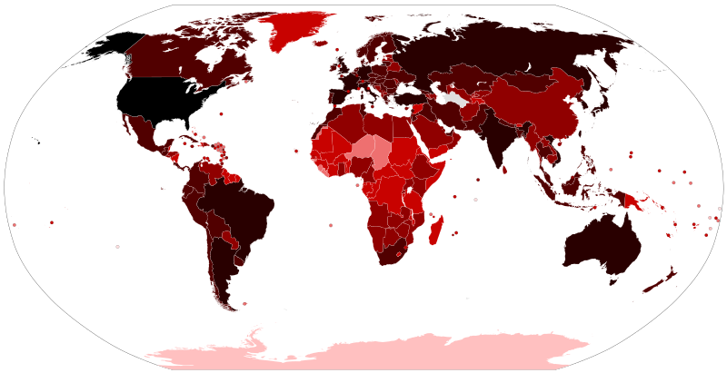
Ofbeeldienge:COVID-19 Outbreak World Map.svg
Uiterlijk

Afmetingen van deze voorvertoning van het type PNG van dit SVG-bestand: 800 × 411 pixels Andere resoluties: 320 × 164 pixels | 640 × 329 pixels | 1.024 × 526 pixels | 1.280 × 657 pixels | 2.560 × 1.315 pixels | 2.921 × 1.500 pixels.
Ofbeeldienge in een ôgere resolutie (SVG-bestand, nominaal 2.921 × 1.500 pixels, bestandsgrootte: 1,72 MB)
Bestandsgeschiedenisse
Klik op een datum/tijd om het bestand te zien zoals het destijds was.
| Datum/tijd | Miniatuur | Afmetingen | Gebruiker | Opmerking | |
|---|---|---|---|---|---|
| huidige versie | 14 jun 2023 14:21 |  | 2.921 × 1.500 (1,72 MB) | AKS471883 | Macao 10000 |
| 25 feb 2023 16:55 |  | 2.921 × 1.500 (1,72 MB) | AKS471883 | Taiwan 10000000 | |
| 17 jan 2023 02:10 |  | 2.921 × 1.500 (1,72 MB) | AKS471883 | Argentina 10000000 Channel Islands 100000 | |
| 24 dec 2022 05:56 |  | 2.921 × 1.500 (1,72 MB) | AKS471883 | Tokelau 5 | |
| 20 dec 2022 03:26 |  | 2.921 × 1.500 (1,72 MB) | AKS471883 | Uruguay 1000000 | |
| 16 dec 2022 03:02 |  | 2.921 × 1.500 (1,72 MB) | AKS471883 | Mongolia 1000000 | |
| 14 dec 2022 11:07 |  | 2.921 × 1.500 (1,72 MB) | AKS471883 | Macao 1000 | |
| 4 dec 2022 05:50 |  | 2.921 × 1.500 (1,72 MB) | AKS471883 | Panama 1000000 | |
| 24 nov 2022 03:09 |  | 2.921 × 1.500 (1,72 MB) | AKS471883 | GUAM | |
| 22 nov 2022 16:47 |  | 2.921 × 1.500 (1,72 MB) | S17003 | USA 100000000 |
Bloadn met dizze ofbeeldienge
Geen enkele pagina gebruikt dit bestand.
Globaal bestandsgebruik
De volgende andere wiki's gebruiken dit bestand:
- Gebruikt op af.wikipedia.org
- Gebruikt op als.wikipedia.org
- Gebruikt op ar.wikipedia.org
- Gebruikt op ar.wikinews.org
- Gebruikt op ast.wikipedia.org
- Gebruikt op az.wikipedia.org
- Gebruikt op be.wikipedia.org
- Gebruikt op bh.wikipedia.org
- Gebruikt op bn.wikipedia.org
- Gebruikt op bs.wikipedia.org
- Gebruikt op ca.wikipedia.org
- Gebruikt op cs.wikipedia.org
- Gebruikt op da.wikipedia.org
- Gebruikt op de.wikipedia.org
- Gebruikt op de.wikinews.org
- Gebruikt op el.wikipedia.org
- Gebruikt op en.wikipedia.org
- User:LightandDark2000
- User:JeremyNguyenGCI/sandbox
- Wikipedia:Top 25 Report/January 19 to 25, 2020
- COVID-19 pandemic by country and territory
- Talk:COVID-19 pandemic by country and territory/Archive 1
- Wikipedia:Top 25 Report/January 26 to February 1, 2020
- Wikipedia talk:WikiProject Medicine/Archive 132
- Wikipedia:Top 25 Report/February 2 to 8, 2020
- Wikipedia:Top 25 Report/February 9 to 15, 2020
- Wikipedia:Top 25 Report/February 16 to 22, 2020
- Wikipedia:Wikipedia Signpost/2020-03-01/Traffic report
- Wikipedia:Top 25 Report/February 23 to 29, 2020
- Wikipedia:Wikipedia Signpost/Single/2020-03-01
- File talk:COVID-19 Outbreak World Map.svg
- Wikipedia:Top 25 Report/March 1 to 7, 2020
- Wikipedia:Top 25 Report/March 8 to 14, 2020
- Wikipedia talk:In the news/Archive 74
- Template talk:COVID-19 pandemic/Archive 1
Globaal gebruik van dit bestand bekijken.


